Sign up for our email newsletter to receive updates on the latest in geospatial technology that will help improve your projects' efficiency, safety, and costs.
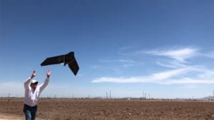
In Arizona and throughout the United States, drone surveys provide revolutionary applications for planning, mapping, monitoring, and imaging on a limitless variety of projects. Considering the relatively recent advent of drone technology, the advances in their capabilities are remarkable. Only since…
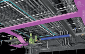
The transformation to 3D data assists engineers, architects, and facilities managers at nearly every stage of a project by simplifying design workflow.

Listen to this Tucson Means Business interview with Mary Darling, CEO and Principal Owner of Darling Geomatics. You’ll learn about her background, starting the company, leading a global, high tech surveying company, and about some of their most interesting and challenging projects. Sign up for our email newsletter to receive updates on the latest in…
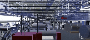
Our 3D scanning services with true color, digital reality data enable projects to advance by keeping teams productive when employees, clients, and stakeholders are working remotely as well as when they are at the office or in the field.
During this time of uncertainty, we at Darling want to assure our customers that we are monitoring the current coronavirus situation closely. As a valued customer it is important that you know Darling Geomatics is open for business.
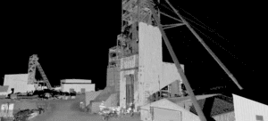
Mine Mapping Services: Survey-Grade 3D Data from Surface to Underground Mine mapping has transformed how the mining industry captures, understands, and manages complex operations, from open-pit surfaces to the deepest underground workings. Watch our latest project video showcasing a complete 3D mine mapping engagement: beginning with an aerial LiDAR scan of the headframe, descending 1,700…
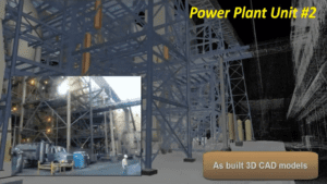
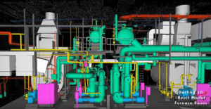
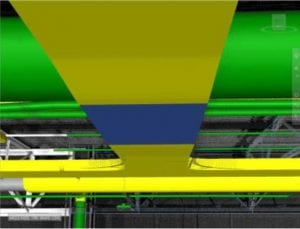
3D models of as-builts help power industry engineers modify and upgrade assets. Our 3D scanning services are safe, fast and accurate to produce digital twins of power plants, substations and other assets before upgrading, and to provide construction verification to spot check work as it progresses. Power companies trust Darling Geomatics. We’ve scanned more than…
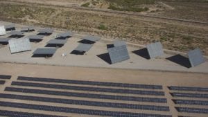
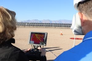
Our aerial thermography for solar panel field evaluations provides data on efficiencies of power generation, panel service life, and return on the investment. Our FLIR-equipped UAVs with Zenmuse XT 640×512 resolution radiometric infrared camera lowers the cost of services that would otherwise require a helicopter.
Federal and state governments set goals of awarding certain percentages of prime and subcontracting dollars to businesses to proactively develop and expand supplier diversity. Our certifications help our clients and teaming partners meet these supplier diversity requirements.
Do you know if your facility meets structural integrity standards before you invest in renovations or modifications? 3D scanning for manufacturing delivers accurate as-built models to assist in project planning and assessment. Safe, fast and accurate 3D as-built models can be used to detect structural deficiencies and design solutions to reduce risk and liability on…
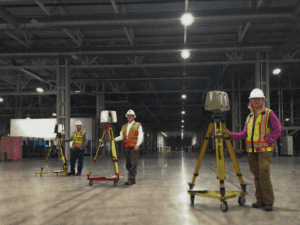
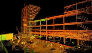
Do you know how we scanned a 1.5 million square foot Mercedes-Benz facility for construction verification in just eight days? Advances in 3D scanning technologies and data analysis software have set a new standard in intelligence for facility owners, architects, engineers and contractors. Read this xyHt magazine article for details.
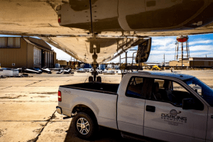
Whenever we have the privilege of working with a company that saves lives, we get excited. In the case of airline safety – we have had the opportunity to be part of a team that designs and installs baffling systems inside the fuel tanks of airlines. The baffling part to the equation is that the…
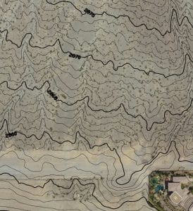
Does your project success depend on accurate ground characteristics? Professional engineering quality topographic maps reduce risk and uncertainty by accurately depicting slopes, undulations, water flow and hazards necessary to design and planning. Drones supplement ground crews and replace manned aircraft, reducing time and cutting costs of producing topographic maps.
Do you wonder why your heating and air conditioning bills are high? Our energy audits use infrared thermal imaging from a drone to provide facility owners with accurate, actionable information to correct energy loss, imbalances, and inefficiencies. Do you worry about the condition of your roof after storms? We can provide additional roof condition data…

Our drone surveying and mapping services provide surveying and mapping services provide hydrologists, engineers and others with accurate digital data for flood stage calculations, topographical maps, and 3D visualizations, reducing the risk of design errors, lowering project costs and improving safety: High-flow simulations: 3D digital data is used for high-flow simulations to plan for 100, 300,…
See how this manufacturing plant owner found out exactly where and how much their final construction differed from their design plan. Advances in 3D scanning technology and data analysis software have set a new standard in intelligence for facility owners, architects, engineers and contractors. We can now detect, measure and display 100% of the variances between design…
- « Previous
- 1
- 2
- 3
- 4
Sign up for our email newsletter to receive updates on the latest in engineering technology that will help improve your projects' efficiency, safety, and costs.