SERVICES:
UAV Drone Surveying & Mapping — What We Deliver
The global drone surveying market is forecast to reach USD 1.97 billion in 2025, rising at a CAGR of 19.3%—demonstrating rapid uptake of aerial mapping across sectors.
Our drone survey services deliver precise aerial data for land mapping, construction, and engineering projects. Using cutting-edge drones and FAA-certified pilots, we help you complete surveys faster, safer, and more affordably than traditional methods. The benefits of drone surveying are evident in its streamlined data collection process. Using drones equipped with AI-powered LiDAR scanners and high resolution cameras, we gather high quality data quickly and safely, covering vast land areas in a single flight.
The drone surveying data collected can be transformed into a wide array of customizable deliverables, including high-accuracy 2D and 3D maps and 3D models. This cutting-edge approach ensures you receive precisely what your project team requires, rapidly and safely. Our real-time aerial imagery and data processing capabilities enhance project efficiency and decision-making.
Faster, More Affordable Than Traditional Survey Methods

")
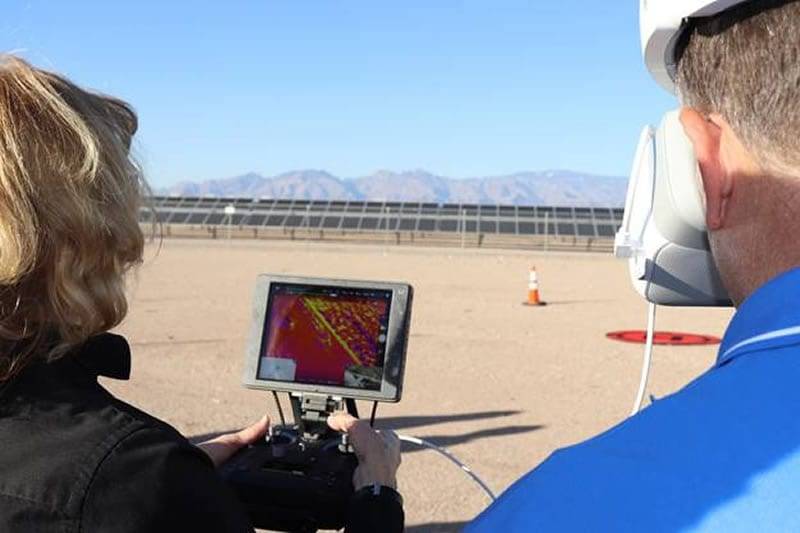
Precise Point Data with UAV Assisted AI
Our drone surveys boast high accuracy by integrating precise survey control point data with the latest UAV and AI technologies, making your project mapping safer and more reliable and affordable from the outset. Trusted by professionals across various industries, our 2D and 3D aerial surveying data is relied upon by engineers, designers, developers, and urban planners. Emergency responders, insurance companies, forensic experts, construction managers, and facilities managers in both government and industry also depend on our high-quality work.
Our drone surveying services include:
- Aerial LiDAR
- Thermal Imaging
- Engineering-Grade Drone Surveying and Mapping
- Survey Control and Aerial Targets
- Topographic Mapping
- AutoCAD Civil 3D Deliverables
We use the latest technology in mobile mapping systems on land vehicles and drones. This helps us collect engineering grade geo-referenced point clouds for many different uses. This technology combines high resolution laser scanning with precise positioning to deliver accuracy, repeatability, and measurable results.
UAV surveying collects high quality data for construction projects. This data is used for as-builts, digital twins, and 3D maps. It helps with design, analysis, planning, and monitoring.
Learn how drone surveys are used for 3D flood simulations.
Rapid, Safe UAV Data Collection Across Any Terrain
A drone surveying company can help maximize efficiency. By speeding up and simplifying the data collection process, the time that used to be spent on data acquisition can be better spent on analyzing more comprehensive data and on strategic planning.
How UAV Drone Surveying Cuts Project Time and Cost
The Darling Geomatics team helps your project stay on course and on budget by reducing the time spent accurately collecting millions of survey points from months or weeks — to only a few days.
Utilizing drone technology reduces surveying costs without sacrificing quality and reduces risks to staff by limiting time spent on the ground — drones acquire data from safe distances, eliminating danger. Darling Geomatics pilots can fly between 1000 - 2000 acres in a single day, depending on conditions and drone type.
Since pilots stay safely out of harm’s way, the necessity of work stoppage to accommodate surveying is avoided, making drone surveying even more cost efficient.
The massive point cloud created by drone surveying can be used to create a variety of maps and models. Further, the sheer volume of data reduces the likelihood of a repeat visit.
What Our Clients Say About Our UAV Drone Mapping Results
 “When delineating flood risk or floodplain limits for design purposes we are using multi-dimensional analysis in our hydraulic modeling software packages. Our inputs to our models require a true depiction of the terrain to give accurate results and that starts with a good foundation.
True color digital orthomosaic images and photogrammetry data delivered from the UAV flights by Darling Geomatics have proven to be a comparable depiction of the terrain that previously was only available with an airplane flight, only more timely.
We have found that the UAV generated aerial photographs and digital topographic data is more cost effective for our clients as well.”
Mr. Scott Altherr
CMG Drainage Engineering, Inc.
Why Project Owners Trust Darling Ltd. for UAV Drone Surveying
GIS-Ready UAV Drone Mapping Data & Spatial Analysis
Standing behind our UAV technology is our decades of precision surveying experience. The experts our drone surveying company employ are FAA-licensed pilots who fly our FAA-registered aircraft. Our pilots also have four different FEMA damage assessment certifications, thermography certification and more. Survey grade ground control and fixed wing and quadcopter drones acquire latitude, longitude, and elevation (x, y, and z) data accurate to within +/- 3 – 6 cm (1.2 - 2 in).
UAV Drone Surveying Solutions by Industry
Whether you need to get an as-built survey in order to expand a hospital wing, gather data on the efficiency of your solar panel field, create a floodplain simulation, or obtain measurable orthomosaic photographs of a golf course, drone surveys deliver solutions.
The Darling Geomatics team helps your project stay on course and on budget — and increase safety — by reducing the time spent accurately collecting millions of survey points from months or weeks to only a few days.
Flexible UAV Survey Deliverables Tailored to Your Project
Our drone surveying experts Arizona and throughout the United States can deliver data in any CAD, non-CAD, 2D and/or 3D format you require:
UAV Drone Mapping & Surveying — Frequently Asked Questions
Darling Ltd. Certifications, Licenses & Industry Affiliations
Darling Geomatics is proud to be a member of the following:


Learn More About Our Aerial Drone Surveying Services
- Using Drones and LiDAR to Map 3D Models of a Gold Mine (Case study)
- 3D Drone Topography, UAV Photogrammetry, and LiDAR Services (Applications, Drone)
- What is the difference between UAV, UAS, and Uncrewed Drone Technology? (Blog article)
- 3D Mine Mapping with Drones (YouTube video)