Sign up for our email newsletter to receive updates on the latest in geospatial technology that will help improve your projects' efficiency, safety, and costs.

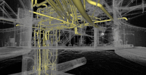
For anyone who has worked through a Scan to BIM project before, the workflow makes intuitive sense once you’ve seen it end to end. For teams evaluating it for the first time, the process can feel like a black box – you hand over site access, and eventually a Revit model arrives. What happens in…
If you’ve started researching 3D scanning options for a construction project, you’ve probably encountered both terms. LiDAR and photogrammetry are the two most widely used technologies for capturing spatial data on construction sites, and at first glance they seem to do the same thing: fly a drone over a site, produce a 3D model, get…
Survey Errors, Discrepancies, and Boundary Disputes: What Causes Them and How Professional Surveyors Resolve Them Anyone who has spent time in the land surveying profession knows this to be true: no two parcels tell exactly the same story. Title documents say one thing, physical monuments say another, and the neighbor’s fence sits somewhere in between.…
Uncrewed vs. Unmanned: Why the Terminology Shift in UAV Surveying Matters More Than You Think Language in technical industries rarely changes by accident. When the words professionals use to describe their tools and methods start shifting, it usually means something real is happening underneath – a change in how the work is actually being done,…

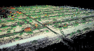
The Changing Landscape of Site Planning Decades ago, mapping a massive parcel of land meant sending crews out for weeks. They would hike through rough terrain, setting up equipment and recording points one by one. It was a slow and physically demanding process. Today, the demands of civil engineering and land development move much faster.…

Building owners face a persistent challenge. Energy costs consume substantial operational budgets while aging building envelopes deteriorate invisibly behind walls and above ceilings. Traditional inspection methods require scaffolding, building access equipment, and production shutdowns that cost more than the inspections themselves. Meanwhile, hidden moisture intrusion, missing insulation, and air leakage continue draining resources. UAV thermal…

Modern manufacturing success depends on measurement precision measured in microns. A single misaligned component can halt production lines for hours. Dimensional deviations of millimeters cascade into quality failures costing thousands in scrap and rework. In this environment, industrial metrology has evolved from occasional verification to continuous precision monitoring that keeps manufacturing operations competitive. What Manufacturing…
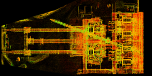
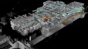
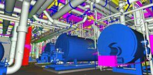
A digital twin is more than a 3D model. It’s a living, data-rich replica of a physical asset that supports real-time decision-making, predictive maintenance, and operational planning. The foundation of any useful digital twin is accurate geometry, and that’s where LiDAR scanning comes in. LiDAR (Light Detection and Ranging) captures millions of precise measurements in…
If you’ve been in manufacturing project management for more than a few months lately, you’ve probably heard someone mention reality capture or digital twins in a meeting. Maybe it was during a facility expansion discussion, or when someone was trying to solve a clash detection problem. These terms get thrown around a lot, but what…
The land surveying industry has changed dramatically over the past decade. What used to take weeks of manual fieldwork can now be accomplished in a matter of hours. Drone surveying has emerged as a game-changer for professionals who need accurate, comprehensive data without the traditional time and cost constraints. At Darling Geomatics, we’ve seen firsthand…
Construction projects rarely go exactly as planned. Regulations change, lenders impose new requirements, and municipalities demand documentation you never saw coming. Understanding when an as-built survey becomes necessary can save your project from costly delays and compliance issues. At Darling Geomatics, we see the same question repeatedly: “Do I really need an as-built survey?” The…
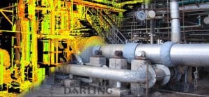
3D scanning has transformed the way projects are planned, designed, and built. Instead of relying on limited measurements and drawings, engineers, architects, and developers now have access to highly detailed digital models that mirror reality. At Darling Geomatics, our 3D scanning services deliver data-rich insights that help clients make smarter decisions, reduce errors, and save…
Tucson Continues to Grow Darling Geomatics is proud to announce that we have been awarded the 2025-2026 on-call land surveying contract for the City of Tucson. This award highlights our decades of experience, dedication to precision and safety, and commitment to supporting the growth and infrastructure of our community. What is an On-Call Land Surveying…
For years, the concept of a digital twin sounded futuristic: something reserved for aerospace labs or advanced manufacturing plants. But in 2025, that’s changed. Digital twin technology is rapidly becoming essential for construction sites and industrial property management. Today’s digital replicas are more than models And if you’re in the business of building, operating, or…

Drone Surveying FAQs: Everything You’ve Wanted to Ask (But Didn’t Know Who to Ask) Drone surveying is revolutionizing the world of geospatial data collection, but for many engineers, developers, and project managers, it remains a mystery. In this blog, we tackle the most frequently asked questions about drone surveying – the ones people hesitate to…
Mining has been a cornerstone of Arizona’s economy for over a century, producing copper, gold, silver, and a range of other minerals critical to industries worldwide. But behind every successful mining operation is a foundation of precise, detailed land surveying. At Darling Geomatics, we understand how crucial accurate land surveys are to the success, safety,…
Hyperspectral imaging and LiDAR represent two of the most powerful remote sensing technologies available today. While hyperspectral sensors capture detailed spectral signatures across hundreds of wavelengths to identify materials, LiDAR uses laser pulses to create precise 3D terrain models. Understanding when to deploy each technology-or combine them-is critical for geospatial projects ranging from mineral exploration…
In recent years, the advancement of LiDAR systems and 3D scanning technology has revolutionized several industries by providing highly accurate, high-resolution data and models. LiDAR, which stands for Light Detection and Ranging, utilizes laser light to measure distances and generate detailed maps and models. As we look to the future, it’s clear that innovations in…
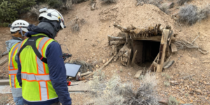
Let’s talk about something exciting that’s transforming the mining industry: 3D laser scanning technology. If you’re involved in mining operations, you know how crucial it is to understand both your surface and underground environments. What if I told you there’s a way to create an incredibly detailed digital model that captures everything from your surface…
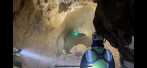
The evolution of underground mapping technology has transformed how we understand and navigate complex mine networks. Through the integration of LiDAR (Light Detection and Ranging) technology, geological surveys have reached unprecedented levels of accuracy and detail, revolutionizing how we approach underground mine mapping projects. The Power of Precision Modern LiDAR systems can capture millions of…
Sign up for our email newsletter to receive updates on the latest in engineering technology that will help improve your projects' efficiency, safety, and costs.