SERVICES
Thermal Imaging
")
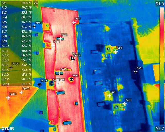
Aerial radiometric imagery provides georeferenced data on every pixel of the thermal image.
SERVICES:
Thermal imaging reveals what the eye cannot see. Using advanced infrared thermography, Darling Geomatics captures radiometric temperature data across industrial facilities, commercial buildings, utility infrastructure, and environmental sites. Our drone-mounted thermal cameras detect equipment failures before they happen, identify energy inefficiencies costing thousands annually, and locate structural defects invisible to conventional inspection methods. Whether you're managing solar arrays in Arizona, monitoring electrical substations, or conducting building envelope assessments, our ITC-certified thermographers deliver georeferenced thermal data with sub-degree accuracy—pinpointing exactly where problems exist and what they're costing you.
What is Thermal Imaging?
Thermal imaging, also called infrared thermography, measures infrared radiation emitted by objects to create visual heat maps showing temperature variations across surfaces. Unlike visual cameras that capture reflected light, thermal cameras detect emitted heat signatures—revealing hot spots, cold spots, moisture intrusion, and energy loss patterns invisible to the naked eye.
Modern radiometric thermal cameras used by Darling Geomatics capture precise temperature data for every pixel in an image, not just colors representing relative warmth. This means our deliverables include actual temperature measurements you can analyze, compare over time, and use to make data-driven maintenance decisions. Our FLIR-equipped drones and Zenmuse XT 640×512 resolution sensors detect temperature differences as small as 0.05 degrees Celsius, with thermal sensitivity capable of identifying problems weeks or months before equipment failure occurs.
Accurate, Actionable Thermography
Our aerial radiometric imagery detects “invisible” leaks, areas prone to overheating before they cause equipment failures; hot and colds spots caused by thermal imbalances and a wide variety of other thermal anomalies.
Georeferenced data on every pixel of the thermal image pinpoints locations to prioritize repairs and maintenance and improve efficiency.
For environmental and wildlife surveys, aerial thermal imaging inspections are safer than other techniques and lowers the cost of services that would otherwise require manned aircraft.
Thermal imaging by ITC-certified experts at Darling Geomatics
Darling Geomatics deploys the latest thermal imaging technology for maximum accuracy and reliability:
FLIR thermal cameras with radiometric capabilities capturing absolute temperature measurements, not just relative heat patterns. Our sensors measure temperatures ranging from negative twenty degrees Celsius to over six hundred fifty degrees Celsius with accuracy within two degrees—ideal for both ambient environmental monitoring and high-temperature industrial processes.
Zenmuse XT thermal cameras featuring 640×512 pixel resolution delivering crisp, detailed thermal imagery suitable for analysis and reporting. Higher resolution means we can detect smaller anomalies from greater distances, reducing flight time and inspection costs.
Georeferenced thermal data integration, combining GPS coordinates with every thermal measurement. This allows precise location identification for maintenance crews and enables year-over-year comparisons to track equipment degradation and efficiency trends.
ITC-Certified Expertise You Can Trust
Thermal imaging interpretation requires specialized training and experience. Our team includes Infrared Training Center certified thermographers who understand not just how to capture thermal images, but how to analyze them correctly. Combined with FAA-licensed drone pilots and professional land surveyors, Darling Geomatics offers comprehensive expertise spanning data acquisition, geospatial accuracy, and thermographic analysis—ensuring you receive actionable insights, not just pretty pictures.
Thermal Imaging Applications
Industrial & Electrical Inspections
Electrical systems generate excess heat at points of high resistance—loose connections, overloaded circuits, corroded components, and failing transformers. Our thermal imaging identifies these anomalies before they cause outages, fires, or catastrophic equipment failure. We inspect electrical panels, switchgear, substations, transmission lines, and distribution systems for utilities and industrial facilities throughout the Southwest. In Arizona and Nevada alone, thermal inspections have reduced unplanned downtime by up to thirty percent by enabling predictive maintenance instead of reactive repairs.
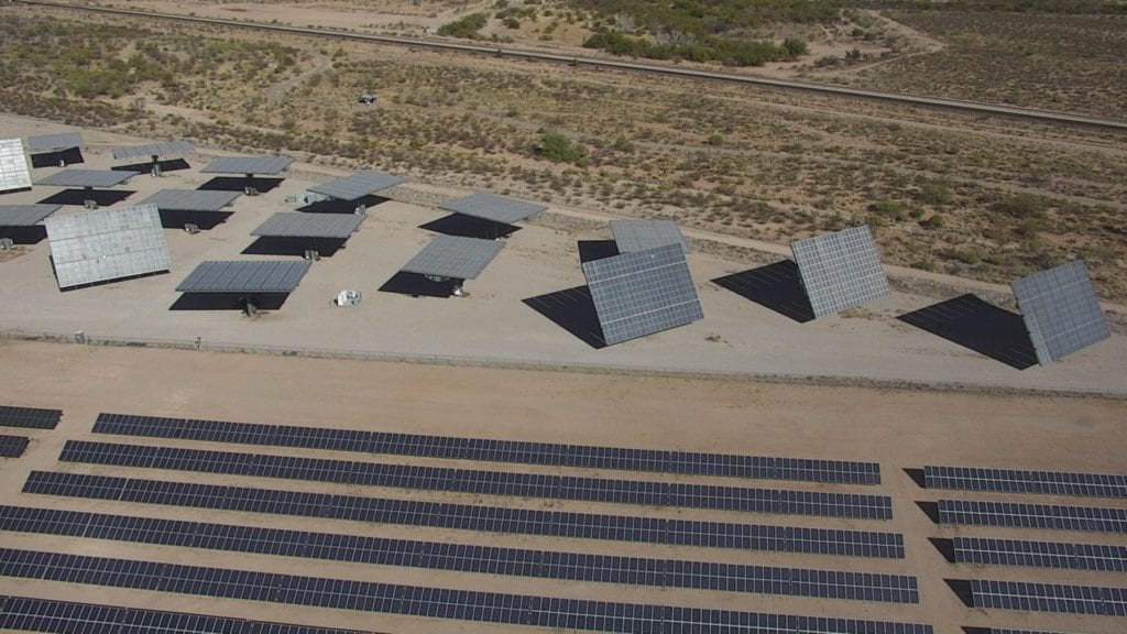
Solar Panel & Renewable Energy Systems
Solar farms depend on thermal imaging to maximize energy production and return on investment. Our drone-mounted thermal cameras scan thousands of solar modules in hours, detecting hotspots caused by cell defects, connection failures, and soiling issues that reduce panel efficiency. Studies show thermal inspections identify failing modules up to thirty percent faster than manual ground inspections. We've conducted solar thermal surveys across Arizona, Nevada, and California, helping operators maintain peak performance and meet warranty compliance requirements.
Building Envelope & Energy Audits
Missing insulation, air leakage, moisture intrusion, and thermal bridging waste energy and compromise building performance. Our georeferenced thermal imagery maps exactly where heat loss and gain occur across roofs, walls, windows, and foundations. Commercial property managers use our thermal data to prioritize weatherization investments, verify construction quality, and reduce HVAC loads. Building envelope thermal inspections typically identify energy efficiency improvements that pay for themselves within two years through reduced utility costs.
HVAC & Mechanical Systems
Overheating motors, failing bearings, misaligned belts, and clogged filters all generate thermal signatures before mechanical failure. Our industrial thermal inspections monitor pumps, compressors, fans, boilers, chillers, and process equipment—catching problems during routine operation without shutting down production. This predictive maintenance approach extends equipment life, prevents costly emergency repairs, and maintains operational efficiency.
Environmental & Wildlife Monitoring
Aerial thermal imaging provides safe, non-intrusive methods for wildlife surveys, water temperature mapping, and environmental assessments. Our drone-based thermal surveys cost significantly less than manned aircraft while delivering higher resolution data. We've supported search and rescue operations, habitat studies, and water resource management projects across the Southwest.
Deliverables in a wide variety of formats
Every Darling Geomatics thermal imaging project includes customized deliverables matched to your workflow and analysis requirements:
- Radiometric JPEG and TIFF images with embedded temperature data for every pixel, compatible with FLIR Tools and other thermographic analysis software
- Georeferenced thermal orthomosaics providing seamless coverage of large areas with precise coordinate information for GIS integration
- Annotated thermal reports highlighting identified anomalies with temperature measurements, recommended priorities, and GPS coordinates
- Temperature differential analysis comparing baseline and follow-up inspections to track degradation or verify repairs
- Video thermal footage for dynamic inspections of moving equipment or comprehensive facility walkthroughs
- Raw thermal data files for clients who prefer to conduct their own analysis using specialized software
We work with your existing systems and preferences—whether you need KML files for Google Earth, shapefiles for ArcGIS, or PDF reports for stakeholder presentations. Our goal is delivering thermal intelligence in the format most useful for your decision-making process.