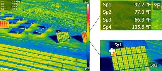
Aerial radiometric imagery provides georeferenced data on every pixel of the thermal image
Our aerial thermography for solar panel field evaluations provides data on efficiencies of power generation, panel service life, and return on the investment. Our FLIR-equipped UAVs with Zenmuse XT 640×512 resolution radiometric infrared camera lowers the cost of services that would otherwise require a helicopter.
- Reduce costs - Our drone inspections greatly reduce the cost of solar field inspections by eliminating helicopter rental, pilot payment, fuel bills, and the other costs associated with bringing it all together.
- Improve safety - Drone thermal imaging inspections are safer than other techniques.
- Detect defects early - Anomalies associated with defects, damage, poor connections, and defective bypass diodes are easily detected and documented. Temporary “shadowing” from debris or other contaminants is also detected and documented for required repairs and/or maintenance.
- Fast - Field work is completed within days, saving time and money. Large scale projects can be monitored monthly in a matter of hours.
- Pinpoint accuracy - Each pixel contains x, y, z coordinates and temperature to produce an accurate energy efficiency audit.
- Rely on our experts - Our team includes certified thermographers and FAA licensed commercial UAV pilots with the expertise and experience to safely execute solar inspection projects and deliver quality results.
- Flexible data formats - Deliverables in a wide variety of formats: FLIR reports, AutoCAD, flythroughs and jpgs.

True color aerial photos can be taken at virtually any scale necessary. Our 30x zoom lens allows close-up views from a safe distance.
Sign up for our email newsletter to receive updates on the latest in engineering technology that will help improve your projects' efficiency, safety, and costs.
Sign up for our email newsletter to receive updates on the latest in geospatial technology that will help improve your projects' efficiency, safety, and costs.
