If you've ever dipped a toe into the world of remote sensing, you've probably heard a lot about hyperspectral imaging and LiDAR. Both technologies are indispensable in modern geospatial work, but they’re often misunderstood or lumped together. At Darling Geomatics, we use both technologies extensively—sometimes independently, sometimes in tandem—to support everything from large-scale environmental assessments to high-precision engineering design.
So, what exactly sets these two powerful tools apart?
Let’s break it down.
Hyperspectral Imaging: Seeing Beyond the Visible
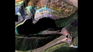
Aerial Hyperspectral and LiDAR Imaging of Pit
Hyperspectral imaging captures light across hundreds of narrow spectral bands, far beyond what the human eye can perceive. Where a standard RGB image gives you three channels (red, green, blue), hyperspectral sensors can offer hundreds of channels—spanning the visible, near-infrared (NIR), and shortwave infrared (SWIR) parts of the electromagnetic spectrum.
This means you’re not just capturing an image; you’re capturing a spectral fingerprint of every pixel in the scene. Different materials—whether it’s soil, vegetation, minerals, or man-made surfaces—reflect and absorb light differently across the spectrum. Hyperspectral data reveals these subtle differences with incredible precision.
LiDAR: Capturing the Third Dimension
Where hyperspectral imaging is all about spectral detail, LiDAR (Light Detection and Ranging) is focused on spatial precision. It works by emitting laser pulses (typically in the near-infrared range) and measuring the time it takes for those pulses to bounce back from surfaces. The result? A dense point cloud that maps the 3D structure of the landscape, buildings, vegetation, and more.
LiDAR is the go-to technology for generating high-resolution digital elevation models (DEMs) and bare-earth models, even in areas with dense canopy cover. It penetrates through gaps in foliage to capture the ground surface beneath—a huge advantage in forested or vegetated areas.
Darling Geomatics has deployed LiDAR in some of the most technically challenging environments in the Southwest. For example, for Excelsior Mining Company, Darling Geomatics conducted mineral mapping of an Arizona copper-processing mine using hyperspectral and LiDAR sensors mounted on drones. This produced precise 3D mineral maps, enabling the client to identify exact locations and prevalence of existing minerals, thereby streamlining extraction and processing operations.
Key Differences at a Glance
| Feature | Hyperspectral Imaging | LiDAR |
| Primary Output | Spectral data cube (hundreds of bands) | 3D point cloud data |
| Focus | Material composition | Surface elevation and structure |
| Penetration Capability | No penetration through canopy or surface | Partial canopy penetration to ground |
| Applications | Vegetation health, mineralogy, agriculture | Topographic mapping, infrastructure design |
| Sensor Type | Passive (requires sunlight) | Active (emits its own laser pulses) |
| Data Size & Processing | Very large and complex | Large but more straightforward |
When to Use Hyperspectral vs. LiDAR
The choice between hyperspectral imaging and LiDAR really depends on your objectives.
- If you want to understand what something is, go with hyperspectral. It’s ideal for material identification, chemical detection, and environmental health monitoring.
- If you want to know where something is and what shape it has, LiDAR is your best friend. It’s perfect for terrain modeling, urban planning, volume calculations, and floodplain analysis.
That said, combining both datasets can be a game-changer.
Darling Geomatics offers hyperspectral imaging services that provide accurate, measurable, and repeatable 3D spectral data for large surface areas using drones equipped with advanced hyperspectral and LiDAR sensors. These services are utilized for mineral exploration, including the detection of rare earth elements and lithium, as well as assessing plant health in agriculture and forestry.
Technical Considerations: Accuracy, Resolution, and Cost
From a technical standpoint, both systems can be deployed via drones (UAS), fixed-wing aircraft, or even ground-based platforms, depending on the scope and resolution required.
- LiDAR systems typically offer centimeter-level vertical accuracy, with millions of points captured per square kilometer.
- Hyperspectral systems, on the other hand, focus on spectral resolution rather than spatial accuracy. Still, with modern sensors, spatial resolution can be quite high—often matching or exceeding multispectral systems like those on drones or satellites.
Of course, all that detail comes at a cost. Hyperspectral imaging tends to be more data-intensive and processing-heavy, requiring advanced expertise in calibration, atmospheric correction, and spectral analysis. LiDAR, while still complex, tends to be more plug-and-play when it comes to generating usable terrain models.
Darling Geomatics collaborates closely with global partners who specialize in both systems. This means we can advise clients on the most cost-effective and technically suitable solution for their specific project—whether it’s a feasibility study for solar development, a habitat restoration analysis, or a structural monitoring program.
Final Thoughts
Hyperspectral imaging and LiDAR aren’t competing technologies—they’re complementary. Together, they offer a multi-dimensional view of the world that is unmatched in the geospatial field.
At Darling Geomatics, we don’t just follow the trends—we set them. With over two decades of experience in remote sensing and a history of innovation across the Southwest and beyond, we’re uniquely positioned to help you get the data you need, in the format you need it, with the insights that matter.
Curious how hyperspectral or LiDAR could enhance your next project? Reach out today—we’d love to talk tech and explore how we can help you see your world more clearly.
Sign up for our email newsletter to receive updates on the latest in engineering technology that will help improve your projects' efficiency, safety, and costs.