When American settlers penetrated the Kentucky wilderness in the 1770’s, the free-for-all landrush involved a cast of characters ranging from roughshod pioneers to greedy speculators to landed Virginia elite. Land surveyors wielding chains created a jigsaw puzzle of conflicting property lines, and the resulting court battles raged well into the next century.
Modern surveyors have infinitely better tools than their professional forebears, but even using the latest technology that boasts a margin of error of a few centimeters, costly mistakes can still occur without professional expertise to apply the technology. For example, a mathematical calculation early in the process will derail the accuracy of an entire survey. The starting point of a survey is sometimes a faulty survey done decades before. Occasionally, a surveyor relies on an outdated property address and winds up surveying the wrong site. Such a complicated, multi-faceted endeavor as surveying leaves plenty of room for human error.
The High Cost of Surveying Errors
Land surveying mistakes cause problems that reverberate for years to come, costing time, money, and peace of mind. On a building project, they can result in lost time or even the need to halt or raze a work in progress. Surveying errors run the gamut from bitter enmity between neighbors over a rose arbor to expensive, drawn out court battles.
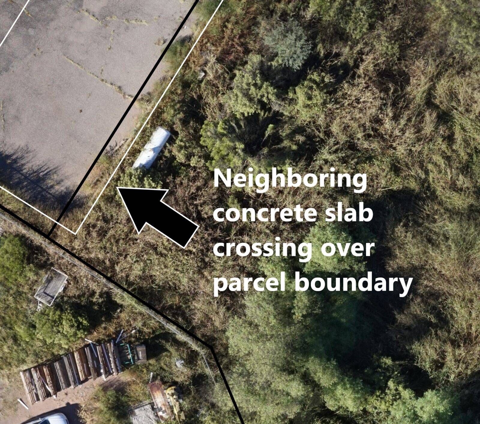
Incorrect boundary lines do not make good neighbors. In residential areas, building a fence or planting a tree on the wrong side of a property line can create considerable uproar. If a structure encroaches even a few inches onto a neighbor’s property, the neighbor has every right to remove it. The importance of an accurate survey cannot be overstressed.
Errors can even result from simple miscommunication on a surveyor’s part. One fairly common issue involves easements. Easements allow non-owners the right to access a property without the owner’s permission. Utility companies, for instance, often need to access property to service lines. An easement of necessity may exist when a landlocked property owner has to cross another person’s land to reach his or her own. Most easements never cause a problem, but they are something a buyer should definitely know about and understand. When a surveyor fails to reveal or properly convey the implications of an easement to a client, the results can be problematic, potentially affecting the land owner’s ability to plant trees or to install a pool, outbuilding, or driveway. A utility company has the right to install equipment without permission, creating a potential eyesore and reducing the property’s value.
The Best Protection Against Land Surveying Mistakes
While you do not have to have a new survey done when purchasing property, you should consider it; property owners need the most accurate information possible. A well-executed land survey describes everything about a piece of property from the boundary lines and easements to its elevation and flood-potential. You should never assume old surveys are correct. Relying on outdated, possibly flawed survey maps leaves the door open for all types of problems.
A professional land surveyor using state of the art equipment can describe the boundaries of a property to within a couple of inches. A bullet-proof survey provides peace of mind and saves property owners from innumerable headaches down the road.
Sign up for our email newsletter to receive updates on the latest in engineering technology that will help improve your projects' efficiency, safety, and costs.