Arizona's unique blend of expansive deserts, rugged mountains, and rapidly expanding urban centers presents distinct challenges for any land development or infrastructure project. Accurate and timely geospatial data is not merely a convenience but a fundamental requirement for success, ensuring projects are designed, constructed, and managed efficiently and safely.
Traditional surveying methods often struggle to keep pace with the demands of such a dynamic and diverse landscape. This imperative for precision and efficiency drives the adoption of cutting-edge technologies like drone photogrammetry and LiDAR scanning, transforming how comprehensive land surveys are conducted across the Grand Canyon State.
Arizona's Diverse Terrain Demands Advanced Surveying Solutions
The vast and varied topography of Arizona, ranging from the flat expanses of the Sonoran Desert to the steep elevations of the Mogollon Rim and the complex geology of its numerous canyons, necessitates advanced surveying approaches. Conventional ground surveys in these environments can be exceptionally time-consuming, physically demanding, and, in many cases, prohibitively hazardous. For instance, mapping a remote mining claim or planning a utility corridor through a wilderness area requires capabilities beyond line-of-sight methods.
Project managers, engineers, and developers must consider several decision criteria when selecting a surveying method, including the project's scale, site accessibility, the required level of accuracy, budget constraints, and stringent timelines. Ignoring these factors or relying on outdated techniques can lead to significant pitfalls, such as costly rework, project delays, or even design flaws that compromise structural integrity. Advanced solutions offer the ability to capture data across thousands of acres quickly, providing the comprehensive detail needed for everything from environmental impact assessments to large-scale construction.
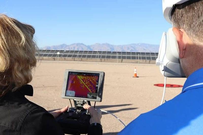
Featured image for Aerial Land Survey Drone: Beyond Traditional Methods
The Precision of Drone Surveying for Arizona Projects
Drone surveying has revolutionized data acquisition for Arizona's diverse projects, offering unparalleled speed and safety. By deploying unmanned aerial vehicles (UAVs) equipped with high-resolution cameras, surveyors can gather vast amounts of information in a fraction of the time compared to traditional methods. This technology is particularly valuable for construction sites, large land parcels, and environmental monitoring where rapid updates are critical.
Rapid Data Acquisition Across Vast and Inaccessible Landscapes
Drones are adept at covering extensive areas quickly, making them ideal for projects like solar farm installations, large-scale agricultural mapping, or expansive real estate developments across Arizona's broad landscapes. What might take a ground crew weeks to survey can often be completed by a drone in mere days. This speed translates directly into accelerated project timelines and reduced operational costs. For example, a developer planning a new housing community near Queen Creek can obtain precise topographical data for hundreds of acres within a day, allowing for immediate commencement of design phases.
Mitigating Risks in Challenging Arizona Environments (e.g., canyons, mountains)
One of the most significant advantages of drone surveying is its ability to reduce human exposure to hazardous conditions. Arizona's rugged terrain, including steep canyon walls, remote mountain ranges, and active construction sites, poses considerable safety risks. Drones can access and map these difficult-to-reach areas from a safe distance, minimizing the need for personnel to navigate dangerous slopes or unstable ground. This enhances safety protocols, reduces potential liabilities, and ensures that critical data is captured even in the most challenging Arizona environments.
Generating High-Resolution Orthomosaics and 3D Models for Planning
The data collected by drones is processed to generate high-resolution orthomosaics and detailed 3D models. Orthomosaics are geometrically corrected aerial images that serve as accurate maps, while 3D models provide rich visual context for site planning, design, and progress monitoring. These deliverables are essential for volumetric calculations of earthworks, precise stockpile management, and creating accurate digital representations of sites. Engineers and planners utilize these detailed models for informed decision-making, from designing drainage systems to simulating future infrastructure developments.
Unlocking Detail with Aerial LiDAR Scanning in Arizona
While drone photogrammetry excels at capturing visual surface data, aerial LiDAR (Light Detection and Ranging) scanning offers a distinct advantage, particularly in environments with dense vegetation or complex surface features. LiDAR systems actively emit laser pulses and measure the time it takes for these pulses to return, creating a highly accurate 3D point cloud of the surveyed area. This technology is indispensable for projects requiring subsurface topographical information.
Penetrating Dense Vegetation to Reveal True Ground Topography
A primary benefit of aerial LiDAR in Arizona's diverse ecosystems, such as riparian corridors or forested areas within national forests, is its ability to penetrate vegetation. Unlike photogrammetry, which captures the canopy surface, LiDAR pulses can travel through gaps in foliage, reflecting off the actual ground beneath. This allows for the creation of a bare-earth digital terrain model (DTM), providing an unobstructed view of the true ground topography. This capability is crucial for accurate hydrological modeling, identifying natural drainage patterns, and planning infrastructure routes where precise ground elevation is paramount.
Capturing Millimeter-Accurate Elevation Data for Engineering
LiDAR technology generates an incredibly dense point cloud, often capturing hundreds of points per square meter, each with sub-centimeter accuracy in elevation. This level of detail is critical for demanding engineering applications where even slight inaccuracies can have significant repercussions. Projects such as dam safety assessments, highway design, precise grading for industrial facilities, or monitoring subtle geological shifts heavily rely on LiDAR's ability to provide millimeter-accurate elevation data. This precision helps in identifying subtle changes in grade, detecting potential structural issues, and ensuring compliance with stringent design specifications.
Essential Applications in Infrastructure Development and Utilities
The highly accurate data produced by aerial LiDAR scanning has become indispensable for a wide range of infrastructure development and utility projects across Arizona. It is extensively used for mapping power line corridors, ensuring clearance from vegetation and identifying potential encroachment, as well as for planning and monitoring pipeline routes, optimizing their alignment with minimal environmental impact. In large-scale construction, LiDAR supports detailed site preparation, accurate volume calculations for earthmoving, and geospatial mapping for smart city initiatives. The technology provides the foundational dataset for creating resilient and efficient public works.
Synergistic Power: How Drone and LiDAR Combine for Unparalleled Accuracy
While both drone photogrammetry and aerial LiDAR offer significant advantages independently, their true power is unleashed when they are combined. By integrating data from both technologies, surveyors can create a comprehensive, multi-layered geospatial dataset that leverages the strengths of each, providing a level of detail and accuracy unattainable by either method alone. This synergistic approach is the gold standard for complex projects in Arizona.
Fusing Point Cloud Data for Comprehensive Georeferencing
The process of fusing point cloud data involves combining the high-density visual information from drone-captured photogrammetry with the precise bare-earth elevation data from LiDAR. Photogrammetry excels at capturing surface features with vibrant color and texture, providing an invaluable visual context. LiDAR, conversely, offers superior ground penetration and elevation accuracy. By integrating these datasets, engineers achieve a comprehensive georeferenced model that not only shows what the surface looks like but also reveals the true topography beneath vegetation. This fused data set is critical for accurate site planning and analysis, especially when creating advanced 3D scans.
Enhancing Data Density and Completeness for Complex Sites
Combining drone photogrammetry and LiDAR significantly enhances the overall data density and completeness of a survey. In areas with mixed terrain, varying vegetation, and complex structures, one technology may compensate for the limitations of the other. For instance, LiDAR can fill in crucial gaps in elevation data where dense tree canopies obscure the ground for photogrammetry, while photogrammetry provides the rich textual detail of buildings and infrastructure that LiDAR might represent as simple geometric forms. This dual approach ensures that every aspect of a site is meticulously captured, resulting in a more robust and holistic digital representation for project stakeholders.
Achieving Engineering-Grade Geospatial Information
The fusion of drone and LiDAR data delivers truly engineering-grade geospatial information. This combined dataset provides the highest level of accuracy, detail, and reliability required for critical infrastructure projects, environmental compliance, and precise volumetric calculations. Engineers can confidently use this information for detailed design, construction planning, quality control, and as-built documentation. This integrated approach ensures that projects in Arizona are not only completed efficiently but also with an unwavering commitment to precision and safety, establishing a solid foundation for future development and maintenance. The result is a digital asset that supports every phase of a project's lifecycle, from initial concept to ongoing operations.
Driving Efficiency and Reducing Project Risk for Arizona Construction
Accelerated Project Timelines from Planning to As-Built Documentation
Modern geospatial survey techniques, particularly drone and LiDAR mapping, fundamentally transform project timelines across Arizona's construction sector. By providing rapid data acquisition, these technologies drastically reduce the time traditionally spent on site measurements. A typical 100-acre site, which might take days or even weeks to survey comprehensively using conventional methods, can be mapped in mere hours with a drone-mounted LiDAR system. This accelerated data capture extends from initial topographical surveys for planning and design to crucial progress monitoring during construction and final as-built documentation. Streamlined workflows enable project managers to make faster, more informed decisions, keeping projects on schedule and mitigating potential delays caused by outdated or insufficient information. This efficiency is critical in Arizona's fast-paced development environment.
Cost Savings Through Optimized Earthwork and Material Management
The precision offered by drone and LiDAR surveys directly translates into substantial cost savings for Arizona construction projects. Accurate volumetric calculations for earthwork, stockpiles, and material movement minimize waste and prevent costly over-ordering or under-ordering of aggregates, soil, and other critical resources. Detailed digital terrain models (DTMs) allow for precise cut-and-fill analysis, ensuring that excavation and grading efforts are optimized, reducing fuel consumption, equipment wear, and labor hours. For example, a commercial development project involving significant grading can achieve accurate volumetric analysis with sub-inch precision, enabling contractors to balance earthwork efficiently and significantly cut costs associated with importing or exporting materials. This level of resource optimization is invaluable in managing tight project budgets.
Providing Precision Data for Critical Design and Decision-Making
High-fidelity topographical data and detailed 3D models derived from drone and LiDAR surveys are indispensable for critical design and decision-making processes. Engineers and architects can leverage this highly accurate information to create precise designs, ensuring that structures and infrastructure are optimally integrated with the existing terrain. The ability to visualize the project site in 3D, complete with contours, elevations, and existing features, helps identify potential design conflicts or constructability issues early in the planning phase. This proactive approach prevents expensive redesigns and rework later in the project lifecycle. Furthermore, this precision data facilitates informed decision-making regarding site layout, drainage, and utility placement, ultimately leading to safer, more resilient, and more efficient construction outcomes across Arizona.
Key Arizona Industries Benefiting from Modern Geospatial Surveys
Large-Scale Infrastructure (Roads, Pipelines, Power Lines)
Arizona's expansive landscape necessitates robust infrastructure, and modern geospatial surveys are critical for its development and maintenance. For projects like new road construction, pipeline installations, or power line routing, drone and LiDAR surveys provide rapid and comprehensive corridor mapping. This includes detailed elevation data, existing feature identification, and obstacle detection across vast linear stretches, often in challenging terrain. The ability to collect data safely and efficiently over long distances significantly reduces planning time and costs. Furthermore, these surveys contribute to ongoing asset management by creating accurate baseline models for monitoring changes over time, facilitating proactive maintenance and ensuring the integrity of vital infrastructure for decades.
Mining Operations and Accurate Volume Calculations
The mining industry in Arizona heavily relies on precise and frequently updated volumetric calculations for operational efficiency and regulatory compliance. Drone and LiDAR technologies offer an unparalleled method for monitoring stockpiles, tailings ponds, and pit development. Surveys can be conducted regularly, often weekly or monthly, to provide accurate and regular volumetric updates, enabling mine managers to track material extraction rates, manage inventory, and optimize logistics. Beyond volume, these surveys contribute to operational safety by identifying unstable slopes or potential hazards within the mine environment. The speed and non-intrusive nature of aerial data collection minimize disruption to active operations, making it an ideal solution for dynamic mining landscapes.
Commercial and Industrial Site Development and Monitoring
From new manufacturing plants to expansive commercial complexes, site development in Arizona benefits immensely from advanced geospatial surveys. Prior to construction, detailed surveys provide essential information for site selection, grading plans, and infrastructure layout. During construction, regular drone flights can monitor progress, verify compliance with design specifications, and detect potential issues early. This includes tracking earthwork progress, ensuring proper drainage slopes, and verifying utility installations. Post-construction, the initial survey data can form the foundation for a facility's digital twin, aiding in ongoing management and maintenance. This technology ensures optimal site readiness assessment and continuous progress monitoring, leading to successful project delivery. For organizations aiming for engineering excellence, the National Society of Professional Engineers offers valuable resources on professional standards.
Beyond the Scan: Actionable Deliverables and Digital Twins
From Raw Data to CAD-Ready Models and Intelligent Point Clouds
The true value of drone and LiDAR surveys extends far beyond the initial data capture. Raw point cloud data, comprising millions of individual XYZ points, undergoes sophisticated processing to become actionable deliverables. This transformation involves rigorous filtering, classification, and georeferencing, turning seemingly unstructured data into highly organized and intelligent point clouds. From these refined datasets, engineers and designers can generate a variety of outputs, including 2D topographic maps, 3D surface models (TINs), contour maps, and orthorectified imagery. Crucially, these deliverables are often provided as CAD-ready models or compatible with various GIS platforms, seamlessly integrating into existing design and analysis workflows. This comprehensive data processing pipeline ensures that every scan contributes directly to project progress.
The Role of Digital Twins in Asset Management and Predictive Maintenance
Modern geospatial surveys are foundational to the creation of digital twins, particularly for complex assets and infrastructure in Arizona. A digital twin is a virtual representation of a physical asset, system, or process, updated with real-time data from various sources, including subsequent drone and LiDAR scans. For a large industrial facility or an entire campus, a digital twin allows stakeholders to visualize, analyze, and interact with a precise digital replica. This enables advanced asset management, facilitating everything from space planning and emergency response simulations to vital predictive maintenance strategies. By monitoring the digital twin, potential issues can be identified before they manifest physically, optimizing operational efficiency and extending the lifespan of critical assets. For deeper insights into leveraging this technology, explore how to
Traditional Surveying vs. Modern Aerial Solutions in Arizona: When to Choose Each
Understanding the Strengths and Limitations of Conventional Methods
Conventional surveying methods, such as total stations, RTK GPS, and optical levels, have been the backbone of land measurement for centuries and continue to play a vital role in Arizona. Their primary strength lies in providing extremely high ground-based accuracy for specific points, making them indispensable for precise boundary surveys, legal descriptions, and setting out critical control points. These methods are particularly effective for smaller sites, highly obstructed areas (where aerial line-of-sight is impossible), or when only specific point data is required. However, traditional methods can be labor-intensive, time-consuming for large areas, and may pose safety risks in challenging terrains. Their limitations often involve the sheer scale and speed required for comprehensive data collection on vast development projects.
Evaluating Project Scope, Timeline, and Accuracy Requirements
Choosing between traditional and modern aerial solutions for an Arizona project hinges on a careful evaluation of the project scope, timeline, and accuracy requirements. For large-scale projects like long linear infrastructure, expansive commercial developments, or comprehensive volumetric calculations for mines, drone and LiDAR surveys offer unmatched speed, safety, and efficiency in data collection, dramatically compressing project timelines. For detailed urban planning or frequent progress monitoring, the rapid deployment and data processing of aerial methods are highly advantageous. Conversely, for precise property line demarcation, individual building corner staking, or specific high-accuracy utility tie-ins, traditional methods often provide the necessary localized precision. Understanding the required data resolution needs and project scale is paramount for selecting the optimal approach.
Hybrid Approaches for Optimal Results
Often, the most effective solution for complex projects in Arizona involves adopting hybrid surveying techniques that combine the strengths of both traditional and modern aerial methods. For instance, conventional ground surveys can be used to establish a highly accurate network of control points across a large site. These control points then serve as the precise ground truth for georeferencing and calibrating drone and LiDAR data, enhancing the overall accuracy of the aerial survey. This integrated approach ensures both broad-area coverage and high localized precision. For example, a large master-planned community might use drones for overall topography and earthwork volumes, while traditional methods are employed for individual lot corner staking and utility connections. This careful blend of technologies allows for a thorough cost-benefit analysis, optimizing both efficiency and accuracy. To explore how aerial methods transcend conventional boundaries, refer to insights on aerial land survey drones beyond traditional methods.
Selecting the Right Geospatial Partner for Your Arizona Project
Choosing a geospatial partner in Arizona requires more than just evaluating technological prowess; it demands a nuanced understanding of local intricacies. The ideal firm combines cutting-edge surveying methods with a deep appreciation for the unique regulatory landscape and environmental considerations specific to the state. This strategic selection is paramount to ensuring project success, mitigating risks, and achieving highly accurate and actionable data from inception to completion. A well-vetted partner provides not only superior technical execution but also invaluable advisory support, aligning advanced techniques like Compliance with Arizona Revised Statutes is non-negotiable for any land development or infrastructure project.
Verifying Advanced Technology and Data Processing Capabilities
The efficacy of modern land surveying in Arizona hinges on advanced technology. When selecting a partner, it is crucial to verify their proficiency with tools such as drone-mounted LiDAR, photogrammetry, and sophisticated 3D scanning equipment. Inquire about their specific hardware (e.g., LiDAR sensor models, drone platforms) and software stacks for data processing, modeling, and visualization. An exceptional firm will demonstrate a robust workflow from raw data capture to the delivery of high-resolution point clouds, orthomosaics, and detailed digital terrain models. Furthermore, their capability to create accurate digital twins for asset management or integrate data into Building Information Modeling (BIM) platforms is a strong indicator of their technical edge. Ask for examples of past projects and their specific deliverables to assess the quality and utility of their data processing outputs. This ensures you receive actionable, engineering-grade information rather than just raw scans.
Commitment to Accuracy, Measurability, and Repeatability
The cornerstone of reliable geospatial data lies in its accuracy, measurability, and repeatability. A reputable Arizona surveying partner will demonstrate an unwavering commitment to these principles through rigorous quality control protocols and adherence to industry standards. This includes regular equipment calibration, employing redundant data collection methods, and performing extensive post-processing validation. Discuss their internal QA/QC procedures, their use of ground control points, and their methods for achieving specified survey-grade accuracies, often measured in millimeters for precision applications. For example, a partner might demonstrate how their processes ensure that subsequent surveys of the same area yield consistent, comparable results, which is vital for monitoring changes over time or verifying construction progress. Prioritizing a partner with a transparent and robust methodology ensures that the geospatial information provided is trustworthy and suitable for critical engineering decisions, minimizing the potential for costly errors down the line.
The Future of Land Surveying in Arizona: Innovation and Sustainability
The landscape of land surveying in Arizona is continuously evolving, driven by relentless innovation and a growing emphasis on sustainability. Emerging technologies, particularly advancements in artificial intelligence and machine learning, are set to revolutionize data processing, enabling faster insights from vast datasets acquired via drone and LiDAR. This includes automated feature extraction, change detection, and predictive modeling, which will significantly reduce manual labor and accelerate project timelines. Autonomous drone operations, with beyond-visual-line-of-sight (BVLOS) capabilities, promise to expand the reach and efficiency of data collection, especially across Arizona's expansive and often remote terrains. The integration of real-time data streaming with IoT sensors will also create dynamic digital twins, offering unprecedented monitoring capabilities for infrastructure and environmental management.
Moreover, the future of surveying inherently embraces sustainability. High-tech methods like
The ongoing development of geospatial technology promises to further enhance the precision, speed, and analytical depth available to Arizona's engineers, developers, and land managers. As these advancements become standard, the ability to make informed, data-driven decisions will be more critical than ever, shaping sustainable growth and efficient resource management across the state.
Sign up for our email newsletter to receive updates on the latest in engineering technology that will help improve your projects' efficiency, safety, and costs.