Sign up for our email newsletter to receive updates on the latest in geospatial technology that will help improve your projects' efficiency, safety, and costs.
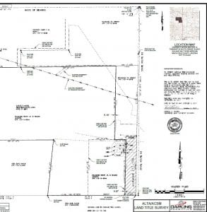
When conducting a commercial property transaction, an American Land Title Association survey (ALTA) will likely be required by the lender or title company or suggested by your attorney. In most cases, title insurance cannot be obtained without an ALTA survey. Far more accurate than a boundary survey, the details presented in an ALTA survey can…
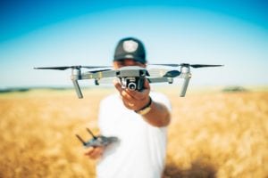
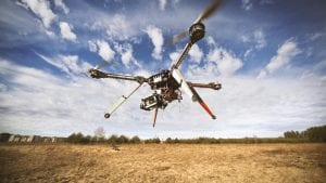
UAV, UAS, uncrewed, unmanned, drone…the lexicon surrounding small, pilotless aircraft can get confusing. Do all those terms refer to the same thing? If not, what distinguishes one from another? How is a drone different from a UAV? What is the difference between uncrewed and unmanned? Drone or UAV? The word drone did not originally designate…

Artificial Intelligence (AI) is rapidly changing the construction industry, and the possibilities and mind boggling. Starting with the design process and ending with a built environment’s decommissioning, AI is playing increasingly vital roles in achieving collaboration and connectivity in construction through the full life cycle to final repurposing and recycling of materials at the end…
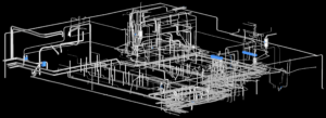
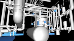
Combining laser scanning, 3D modeling, and AI provides revolutionary efficiencies and innovations never before possible. Highly versatile digital twin solutions are a must for many applications and industries. The extreme versatility of laser scanning and 3D modeling, combined with AI to create “smart” digital twins makes this technology ideal for a host of applications and…
Digital Twins have been around for a little over two decades, but today’s digital twins can employ AI and machine learning, setting them apart from earlier virtual modeling capabilities. They are complex virtual representations built from multiple data sources such as processes, people, devices, and mechanical systems. Digital twins represent not just one process but an entire organization.
For anyone new to thermal imaging, it has been a game changer for so many industries and fields. Thermal imaging, at its most basic, is the visual representation of infrared radiation-or heat-put off by something, be it organic or inorganic. If an object or organic being has a temperature above zero degrees, it emits heat…
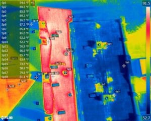
Drone thermography plays so many roles in the construction industry. Combining UAV and infrared (IR) capabilities, the technology can be used to: inspect work monitor and maintain systems diagnose problems early assess and help improve energy efficiency verify proper installation of mechanical systems like HVAC UAV thermography has many advantages over handheld IR technology. Because…
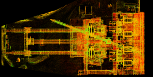
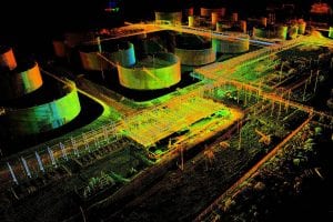
3D mapping and modeling, which are accomplished using point clouds of data collected by laser scanner, have come very far very fast. Anyone around in the infancy of laser scanning can recall how large, heavy, and slow the equipment was. Once the technology became more efficient, affordable and widely available, however, there seemed to be no limit to its uses.
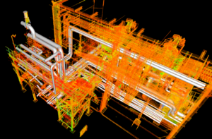
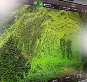
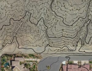
LiDAR created 3D maps and models are made up of individual data points. A point cloud is a massive collection of virtual data points, with each one representing actual points in the real world. These millions of individual data points, taken together, create a usable dataset. Using software to model physical objects in digital space makes point clouds imminently useful.
If time is money–and many argue that it is–then 3D drone surveying delivers a resounding mic drop. Traditional surveying and drone surveying are not even in the same ballpark when it comes to the amount of time it takes to complete a survey. The slowness of traditional surveying methods can contribute to costs running into the thousands of dollars for a single small acreage topographical map.
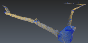
Before advances in underground surveying using 3D scanning technology, inspecting and mapping subsurface facilities was time-consuming, costly, and hazardous. Surveying mines is notoriously tricky, but today’s LiDAR, photogrammetry, and georeferencing tools paired with state-of-the-art software are capable of producing a phenomenal array of maps and models designed to tackle almost any underground conundrum in near real-time. Watching a video of a 3D tunnel scan is mesmerizing.
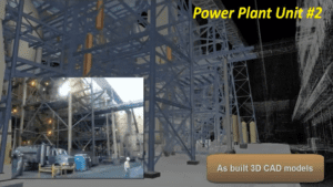
Exactly like the name sounds, an as-built survey is an accurate visual rendering showing a completed construction or engineering project. Today’s laser scanning makes the process fast, efficient, and affordable and will even save money in the long run. Cost reduction is so significant, in fact, the U.S. government General Services Administration (GSA) now requires building information models (BIM) to provide clash detection on every government construction project.
Innovations in mine surveying made possible by state-of-the-art survey technologies have revolutionized mine design and development, environmental and safety monitoring, and volumetric calculation.
Hyperspectral imaging, also known as imaging spectroscopy, refers to the gathering and processing of data from across the vast electromagnetic spectrum.
Modern aerial LiDAR equipment mounted on UAVs makes possible the collection of high resolution elevation data used to create 3D models of objects, detailed Digital Terrain Models (DTMs), and Digital Elevation Models (DEMs).

Mary Darling, Darling Geomatics CEO and Principal Owner, will serve as an Arizona ambassador at Goldman Sachs 10,000 Small Businesses Summit to be held July 18-20 in Washington, D.C. The Summit will be the largest gathering of small business owners in the U.S.
A lot of terms relating to modern surveying technology get muddled: 3D drone scanning, LiDAR scanning, UAV surveying, photogrammetry, etc.
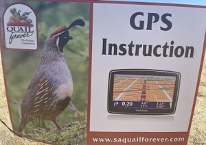
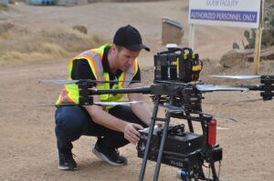
Mary Darling and Rich Darling taught local youth and adult teams on the basics of GPS applications and how they can be applied real time in the field at the annual SAQF Family Day.

Mary Darling, CEO of Darling Geomatics, will be demonstrating high tech digital data collection with LiDAR to high school age girls who are interested in STEM curricula at the 2022 SheTech Explorer Day on March 2, 2022. This is our third year of participating in the event. As a woman-owned business in a technical industry,…
After much waiting, LiDAR’s day has finally come, and we have an array of software platforms powerful enough to handle the huge amounts of data generated by LiDAR scans.
Sign up for our email newsletter to receive updates on the latest in engineering technology that will help improve your projects' efficiency, safety, and costs.